For this I've used Godot Engine and GDScript.
Hello, I am working in a Map Generation project, and I am trying to come up with a Height Map generator for the hills and mountain-ranges. I'm pretty amateur when it comes to programming in general and I mostly try to make everything from zero as I don't know much about game theory or any big programming techniques, so forgive me if anything I've done is ugly or goes totally against any common sense.
Up until now, I've come up with this:
extends Node2D

export(int) var Origin_Min
export(int) var Origin_Max
export(int) var Power

var HeightMap = {}

func _ready():
	new_seed()
	_mountain_range()

func new_seed():

	randomize()
	var random_seed = randi()
	seed(random_seed)
	print(random_seed)


func _mountain_range():

#ORIGINS PHASE - set's origin points for the mountain-ranges
	var OriginList = {}
	for origin in round(rand_range(Origin_Min, Origin_Max)):

		var originPointX = round(rand_range(1, 126))
		var originPointY = round(rand_range(1, 126))
		if OriginList.has(Vector2(originPointX, originPointY)):

			continue
		OriginList[Vector2(originPointX, originPointY)] = {"Power": round(rand_range(1, 5)), "Connected": false}
		HeightMap[Vector2(originPointX, originPointY)] = 3
		$TileMap.set_cellv(Vector2(originPointX, originPointY), 2)

#MOUNTAIN-RANGES PHASE - try to draw mountain_ranges between every origin based on their Power level
	for origin in OriginList:

		for point in OriginList:

			if OriginList[point].Connected:

				continue
			if round(origin.distance_to(point)) <= (OriginList[origin].Power * Power) and round(origin.distance_to(point)) != 0:

				var current = origin
				while current != point:

					var currentDist = round(current.distance_to(point))
					var closerDist = []
					var sameDist = []
					for direction in dir.Directions:

						var step = Vector2(clamp(current.x + direction.x, 1, 126), clamp(current.y + direction.y, 1, 126))
						if step == point:

							OriginList[origin] = {"Power": round(rand_range(2, 3)), "Connected": true}
							current = point
							break
						if round((step).distance_to(point)) <= currentDist:

							closerDist.append(step)
						if round((step).distance_to(point)) >= currentDist:

							sameDist.append(step)
					if round(rand_range(0, 10)) >= 3 and closerDist.size() >= 1: #70% chance of going closer

						current = closerDist[round(rand_range(0, clamp(closerDist.size() - 1, 0, 3)))]
						HeightMap[current] = round(rand_range(2, 3))
						$TileMap.set_cellv(current, 2)
					elif sameDist.size() >= 1: #30% chance of taking a variation

						current = sameDist[round(rand_range(0, clamp(sameDist.size() - 1, 0, 3)))]
						HeightMap[current] = round(rand_range(2, 3))
						$TileMap.set_cellv(current, 2)

#FILL UP PHASE - fill up the rest of the map with height level 0 tiles
	var xCoord = 0
	var yCoord = 0
	for tile in 16384:

		if not HeightMap.has(Vector2(xCoord, yCoord)):

			$TileMap.set_cellv(Vector2(xCoord, yCoord), 0)
		xCoord += 1
		if xCoord == 128:

			xCoord = 0
			yCoord += 1
This code is divided in three parts:
- Set a random number of origins in random locations(excluding borders) and give these origins a power level.
- For each origin, check if it can "link" with each other origin based in its power level, if so, "draw" a mountain-range in between them.
- Draw the rest of the map.
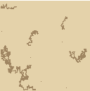
The result is this:

I rarely have some random problems with this code, like an origin point that says that it is nor closer nor at the same distance as another origin point when they are drawing a mountain-range in between them.


